They had guts, those great mariners from the Age of Discovery. Though some are viewed today with a degree of controversy, the likes of Columbus, Vespucci, Cortés and Magellan still hold reputations as bastions of courage and exploration.
How they did it—setting out on uncharted waters aboard creaking wooden sailing vessels, minds abuzz with apprehension of what might lie ahead, suppressing the lingering fear that they might never see land again—will always fascinate me.
Few of us today will ever experience anything approaching that level of long-term anxiety afloat, thanks in large measure to today’s sophisticated marine electronics. They can tell you where you are, where you’re going, when you’ll get there, what’s lies underwater, what might get in your way, and where and when storms might strike. Today’s marine electronics can also recognize and route you around obstacles, and even drive the boat for you.
Most importantly, when used properly by experienced captains, electronics can make you safer. Of course, electronics do not negate the need for prudent seamanship. You still must stay alert and be aware of your surroundings, remain at the wheel, and maintain a lookout and safe speed. But electronics can complement your seamanship skills, particularly in challenging conditions.
One important caveat: Don’t wait until things take a turn for the worse to learn your electronics. Using your devices and interpreting displays should become second nature. This calls for practice and regular refresher sessions when conditions are pleasant to help ensure that you’re ready to effectively use and have confidence in the technology when the real need arises, as described in these five challenging situations in which marine electronics allowed me to pilot the boat with greater safely.
Moonless Passage
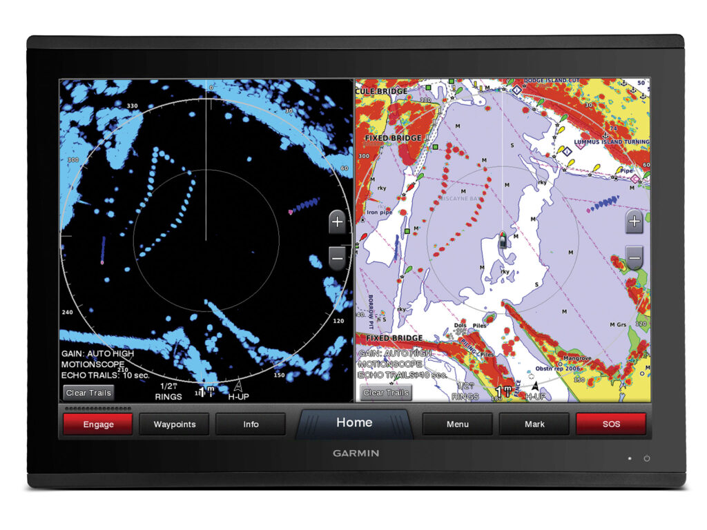
Recommended Electronics: Radar With MARPA, Chart Plotter, AIS, Night-Vision or Thermal-Imaging Camera
You can often prepare yourself for a long nighttime cruise in advance, as I did recently while running 35 miles offshore in the predawn hours for a day of mahi fishing off the coast of Southern California.
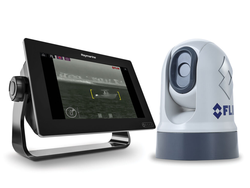
Before leaving the dock, I took the time to make sure that the electronics I had planned to use—radar, chart plotter, AIS and night-vision camera—were functioning properly. You might use instead a thermal-imaging camera from a company such as FLIR, but in this case, I relied on my SiOnyx Nightwave system, which shows the water and objects ahead in a full-color, stable and daylike image on my multifunction display.
Why, you might ask, would I want night vision when I have radar, or vice versa? For me, it boils down to detecting high-profile hazards with radar, while also seeing low-lying objects that radar can’t detect such as lobster-pot buoys or flotsam such as wood pallets and timbers.
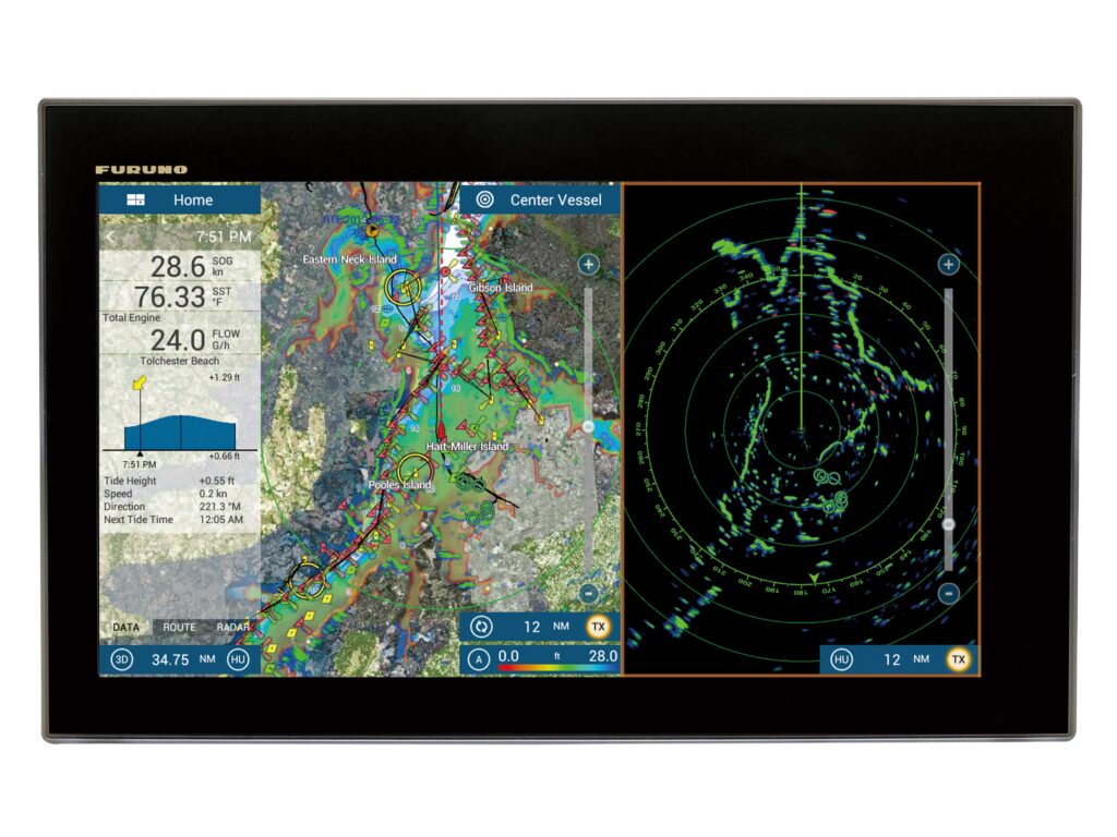
My Mini Automatic Radar Plotting Aid allows me to automatically track targets on my radar to determine their threat level, course, closest point of approach, and time of closest approach.
Some radar systems, such as those from Furuno, Garmin and Simrad, make tracking targets even easier with Doppler technology, which senses the relative motion of returns. Furuno’s Target Analyzer system, for example, automatically changes the color of targets to help you identify when they are hazardous. Green echoes are targets that stay stationary or are moving away from you, while red echoes are hazardous targets that are moving toward your vessel. Echoes dynamically change colors as targets approach or get farther away from your vessel.
An Automatic Identification System offers some redundancy, showing vessels equipped with AIS and confirming their location and identity on both the chart plotter and radar. However, many boats do not broadcast AIS signals, and so I use it only to augment but not replace radar.
My chart plotter provides me with the course and distance to my destination, as well as my current position, offering a sense of place, which I might otherwise lose on a moonless night.
One important tip for using your electronics at night: Dim the screens or use night mode to help preserve your night vision. Bright displays destroy my primary night-time navigational tool: my vision.
Poof! It’s Foggy!
Recommended Electronics: Radar With MARPA, Chart Plotter, AIS, Autopilot, VHF with PA Function and Loudspeaker
I tend to avoid boating in fog, but at least once a season, I get caught as pea soup sweeps quickly across coastal waters. When it happens after dark, it tests my navigational skills like no other condition. Without the right electronics, it can leave boaters wondering whether to try to make safe harbor or stay put. Either choice can turn into catastrophe.
The problem I have with thick fog is its disorienting nature. Without the ability to see my surroundings, I can’t stay on a prescribed course. Try it sometime. Even with a good compass, you will drift off course more quickly than you can imagine, then meander endlessly as you seek to correct, and then overcorrect. That’s why I added autopilot to my list of recommended electronics. It keeps me on course while I use essentially the same electronics in much the same way I use them for nighttime navigation.

Another additional piece of electronics is a VHF radio with (and this is important) a PA function wired to a loudspeaker. As part of the PA feature, some VHFs, such as the Standard Horizon Matrix, have a foghorn function, and it can set for underway or at anchor. While underway, it emits a loud, prolonged blast at 2-minute intervals. In anchor mode, the foghorn signal repeats every minute.
This not only alerts other boats in the vicinity to my presence, but the PA system also has a listen-back feature that helps me hear the sound of other boats approaching my position, so I can prepare to take evasive action if necessary to avoid a collision.
Shallow Threats
Recommended Electronics: Chart Plotter With Auto-Routing, Electronic Chart App, Echo Sounder
The ocean floor is dynamic, especially in shallow nearshore waters where powerful storms, waves and currents shove about bottom mud and sand, unexpectedly piling up shoals. These can catch even local veteran boaters by surprise, especially after a big storm. It happened to me a few years ago when the north side of the main channel at the mouth of the Los Angeles River silted up after a winter storm. Fortunately, my boat did not fetch up, but I did drag the lower unit through the mud for about 50 yards. These days, I stay up to speed on silting with the Navionics Boating app on my mobile phone.
In addition to US government National Oceanic and Atmospheric Administration charts, the Navionics app includes a layer of crowdsourced updates from others boaters. When this layer is switched on, it provides updates from other boaters on subjects such as new shoal areas that might not yet have made it into the official chart update, as well as points of interest and navigation aids. The app also integrates information shared by the ActiveCaptain Community, including navigational hazards.
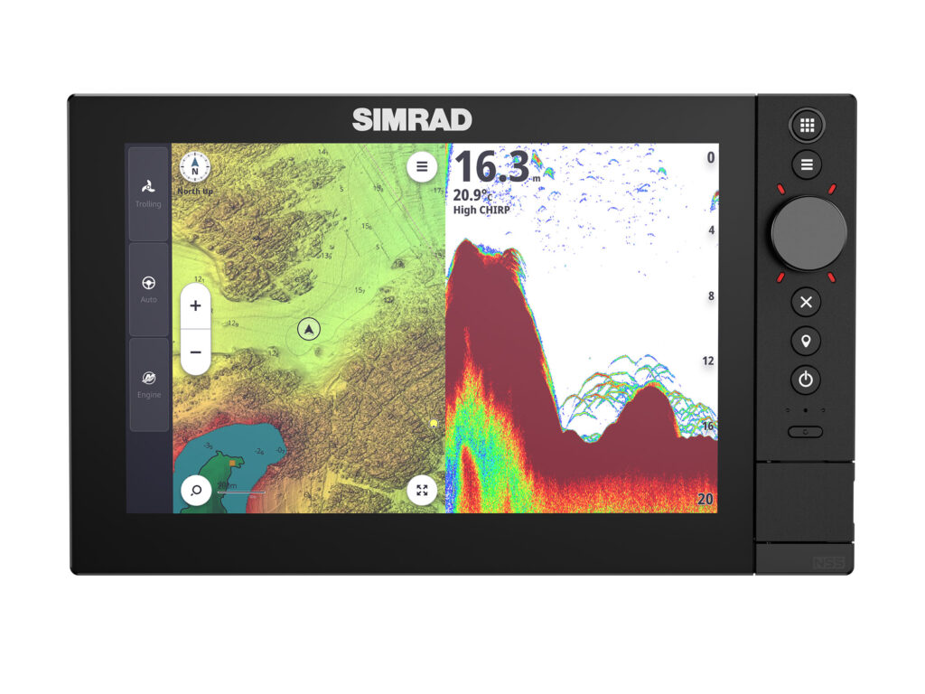
In addition, I have discovered that a chart plotter with auto-routing, as featured on the new Simrad NSS 4 series, can quickly guide me around dangerous shoals and reefs, as well as other hazards. I just plug in my destination as a waypoint, and the system redraws the safest way to get there via a series of waypoints.
Sometimes you just have to slow down and feel your way, especially when navigating backwaters and rivers. That’s when an echo sounder is helpful. I watch the depth carefully to make sure I am in the deepest part of the channel. If the bottom starts to come up, either I change course or reverse out and try another path.
First-Time Visit
Recommended Electronics: Radar, Chart Plotter With Satellite Overlay and Tide Chart, VHF Radio
Occasionally I will venture to new waters north or south of my home port of Long Beach, California, and I sometimes find entering and negotiating a new inlet and port—particularly a large one—somewhat challenging.
I have discovered that radar and a chart plotter—used side by side or as a radar chart overlay—gives me a good idea of how to safely enter the inlet, particularly at night. During the day, when I can see clearly, I sometimes use the 3D feature in course-up mode. Rather than viewing the chart from overhead, this lays out the inlet channel like a highway and can prove intuitive to read, providing greater navigational safety.
Another helpful feature on the chart plotter is the satellite mode that overlays satellite imagery and can show helpful landmarks when exploring new ports. You can zoom in for more detail or zoom out to gain greater context with any of these views.
Standing off and hailing the port master or harbor patrol on the VHF radio is a good idea if you’re unsure about the safety of an inlet. Such was the case on one spring day as I considered entering California’s Oceanside Harbor, which tends to shoal at its mouth. During low tide, big Pacific swells rise up and crest at this inlet. More than one vessel has met its demise here.
I called the harbor patrol on VHF Channel 16, and we switched to talk on Channel 22a. The harbor patrol advised me to hold off until the tide rose, so I checked the tide chart on my chart plotter, which indicated high tide later in the afternoon. I waited until then and found a much safer passage into the harbor.
Read Next: Marine Electronics for Nighttime Safety
Escaping the Storm
Recommended Electronics: Chart Plotter With SiriusXM Marine, Radar, VHF Radio
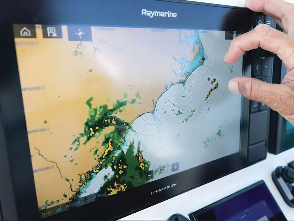
A day of fishing off Key West, Florida, started bright, clear and hot. But by early afternoon, a line of anvil-shaped clouds and an occasional muted boom of thunder in the distance gave me pause for concern.
Fortunately for us, we had the SiriusXM Marine Offshore overlay feature on our chart plotter. With it, we could see on the display a line of major thunderstorms taking shape and tracking quickly in our direction. The SiriusXM Marine Offshore also showed a growing number of cloud-to-ground lightning strikes, accompanied by high winds and waves.
A severe-weather warning from the Coast Guard on the VHF radio confirmed the reports, as did our radar, which picked up the returns of heavy rain in the distance. The fishing had been good, but thanks to our marine electronics, we knew for safety’s sake that the time had come to head back to port.
As we raced ahead of the tempest, I thought of the great mariners from the Age of Discovery and wondered if they could have imagined the tools that everyday boaters like me now have to stay safe. I doubt it. But then, I have little idea what new electronic devices the next season might bring and how they might help me stay even safer.